-
Hurricane Patricia
UPDATE: I hope the people in Mexico in front of Patricia have done all they can to protect life, she is a killer. Hurricane Patricia has now become the strongest HURRICANE ever recorded in history packing deadly category 5 catastrophic sustained winds of 200mph and unreal gusts of up to 245mph with a minimum pressure of 880mb! Basically a huge EF5 tornado. Unprecedented.

Laissez les bon temps rouler!  Going to church doesn't make you a Christian any more than standing in a garage makes you a car.** a 4 day work week & sex slaves ~ I say Tyt for PRESIDENT!
  Not to be taken internally, literally or seriously ....Suki ebaynni
 IS THAT BETTER ?
-
-
10-23-2015 01:12 PM
# ADS
Circuit advertisement

-

We have bands of rain now from the outlyers of this storm ...
Thousands flee as fiercest-ever hurricane nears Mexico
Doyle Rice and David Agren, USA TODAY 3:36 p.m. EDT October 23, 2015
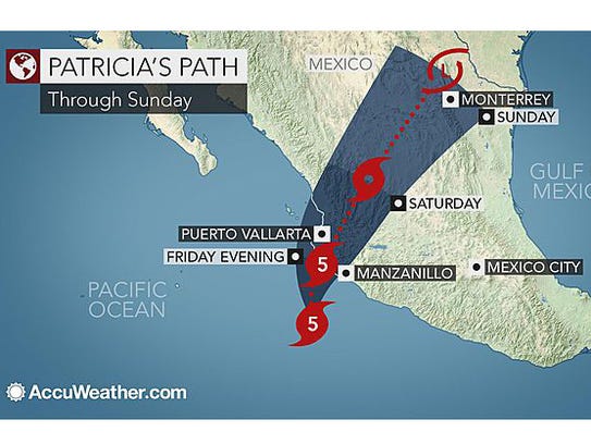
MONTERREY, Mexico — Tens of thousands of people were being evacuated Friday from Mexico's Pacific coast as the strongest hurricane ever recorded in the Western Hemisphere bore down on the popular tourist area packing sustained winds of 200 mph.
The U.S. National Hurricane Center predicted the Category 5 Hurricane Patricia would make a "potentially catastrophic landfall" in southwestern Mexico later in the day.
The center described the storm as the most powerful ever recorded in the eastern Pacific or Atlantic basins. It warned of powerful winds and torrential rain that could bring life-threatening flash flooding and dangerous, destructive storm surge.
"Patricia is one of the strongest tropical cyclones globally ever observed," said WeatherBell meteorologist Ryan Maue, "based on lowest central pressure and maximum surface (and flight level) wind speed since the dawn of aviation-based reconnaissance in the 1940s."
Patricia's winds intensified a whopping 109 mph during Thursday, rising from a tropical storm to a Category 4 hurricane. It was the fastest intensification ever recorded in the eastern Pacific Ocean, according to meteorologist Phil Klotzbach of Colorado State University.
Roberto Ramirez, director of Mexico's National Water Commission, said Hurricane Patricia is powerful enough to lift up automobiles and destroy homes not sturdily built with cement and steel. The storm will also be able to drag people caught outside when it strikes. Those on the coast will be in the most danger, especially people living in the state of Jalisco, which has a population of more than 7.3 million, he said.
In a Category 5 hurricane, a high percentage of framed homes will be destroyed, with total roof failure and wall collapse, according to the hurricane center. Fallen trees and power poles will isolate residential areas. Power outages will last for weeks to possibly months, and most of the area will be uninhabitable for weeks or months.
At 2 p.m. ET, Hurricane Patricia was 85 miles southwest of Manzanillo, Mexico, moving to the north at 12 mph, the hurricane center said. The storm is expected to remain an extremely dangerous Category 5 hurricane through landfall, the agency said.
A total of 50,000 people were expected to be evacuated ahead of the storm, according to civil protection agencies in the three Mexican states of Colima, Jalisco, and Nayarit, Vallarta Daily reported. Those regions house the port city of Manzanillo and the town of Puerto Vallarta, a resort town with a large expatriate community from the U.S. and Canada.
According to the 2010 census, there are more than 650,000 inhabitants in Colima state, more than 161,000 in Manzanillo and more than 255,000 in the Puerto Vallarta municipality.
President Enrique Peña Nieto canceled public events on Friday to put attention on hurricane preparedness. “It will be the strongest hurricane in that has impacted the Pacific in the last 50 years,” he said.
Mexican officials declared a state of emergency in dozens of coastal towns, including Manzanillo and Puerto Vallarta, and ordered schools closed Friday, the Associated Press reported. The city of Puerto Vallarta established 18 shelter locations to house evacuees, and some businesses began boarding and taping up windows late Thursday.
Puerto Vallarta and the neighboring Riviera Nayarit attract thousands of tourists throughout the year, but airlines suspended service with the storm approaching. The Jalisco state government scrambled a fleet of 30 buses to take tourists from the coast to Guadalajara, a five-hour ride inland.
“We are in a very complicated situation, there is an extremely dangerous hurricane about to make impact and we don’t need to put more lives at risk,” said José María Tapia of Mexico’s civil defense system. “(The airports) will be open only to evacuate as many Mexican and foreign tourists that are in that area.”
Tapia said his office is coordinating with the national military, including air, sea and land units, to clear traffic from all routes leading to the waterfront region to help evacuation efforts and allow emergency to enter it. He said foreigners trying to locate their loved ones should work through their consulates in Mexico.
The U.S. Embassy issued a statement calling on Americans to monitor emergency advisories and stay away from the beaches. "As Hurricane Patricia moves inland, it will continue to produce heavy rainfall, wind, and dangerous conditions," the statement said. "Persons located inland in the path of Hurricane Patricia should take appropriate measures to ensure their safety, particularly those located in areas prone to flooding or mudslides."
http://www.usatoday.com/story/news/w...ured/74446334/
Laissez les bon temps rouler! Going to church doesn't make you a Christian any more than standing in a garage makes you a car.** a 4 day work week & sex slaves ~ I say Tyt for PRESIDENT! Not to be taken internally, literally or seriously ....Suki ebaynni IS THAT BETTER ?
-
-
-
-
Strongest Hurricane Patricia makes landfall on Mexico's Pacific coast
2015-10-24
MEXICO CITY, Oct. 23 (Xinhua) -- Hurricane Patricia, the largest ever seen in the Western Hemisphere, made landfall on the Pacific coast of Mexico at around 5:40 p.m., local time, Friday, hitting the municipality of La Huerta in the state of Jalisco.
La Huerta is about 90 kilometers northwest of Manzanillo, an important town in Mexico.
Roberto Ramirez de la Parra, director of the National Commission of Water (Conagua), confirmed the landfall of the hurricane, which brought along strong winds and heavy rains, with waves raging as eight meters high off the coast of Jalisco, Colima and Michoacan.
The maximum sustained winds were 335 km per hour, with gusts of up to 400 km per hour.
Billboards and trees were toppled as the hurricane lashed inland through Jalisco and Colima, packing strong winds and heavy rains.
Porfirio Mendoza Zambrano, the mayor of the municipality of Coahuayana in Michoacan, told the Mexican news agency, Notimex, that there were landslides on roads and rooftops being torn off in his city.
Mexican authorities had by then evacuated more than 50,000 people from the three states by Friday afternoon and advised residents and tourists alike to leave the areas.
It is estimated more than 400,000 people remained in the affected areas.
President Enrique Peña Nieto dispatched 5,000 soldiers, 4,000 sailors and 400 federal police officers to the areas to help with evacuation efforts.
http://news.xinhuanet.com/english/20..._134745215.htm
Laissez les bon temps rouler! Going to church doesn't make you a Christian any more than standing in a garage makes you a car.** a 4 day work week & sex slaves ~ I say Tyt for PRESIDENT! Not to be taken internally, literally or seriously ....Suki ebaynni IS THAT BETTER ?
-
-
Hurricane Patricia: fears of deadly landslides in Mexico as storm brings downpours
Storm is weakening but the worst is yet to come, warns Mexico’s president as reports of flooding and landslides come in before nightfall
six minutes ago
Hurricane Patricia hit Mexico’s Pacific coast on Friday evening, bringing downpours, surging seas and cyclonic winds, but has since weakened, with the main concern moving to fears of landslides caused by heavy rain.
Four hours after making landfall in a relatively unpopulated stretch of Pacific coast, Patricia was downgraded to a category four hurricane. It moved past Guadalajara, Mexico’s second-biggest metropolis, late on Friday night, with strong winds and heavy rain bringing trees down and causing flash flooding across the city.
At 10pm the National Hurricane Centre said: “Now that Patricia has moved inland, while the coastal threat is decreasing, strong and damaging winds, especially at higher elevations, will persist through Saturday morning.
“Very heavy rainfall is likely to cause life-threatening flash floods and mud slides in the states of Nayarit, Jalisco, Colima, Michoacan and Guerrero through Saturday.”
Mexican authorities received reports of some flooding and landslides but there was no immediate word of fatalities or major damage as the storm moved over inland mountains after nightfall. Mudslides are a big concern now as the torrential rain continues. The latest weather alerts warn of heavy rains as far inland as Mexico City. Dozens of people were killed by mudslides in Guerrero during hurricane Manuel in 2013.
The president, Enrique Peña Nieto, led a cabinet meeting late on Friday to discuss safety measures. He warned people to stay alert to the dangers and urged the thousands seeking shelter in refuges to stay put and not go home yet. The worst is yet to come, he said.
Guadalajara’s government set up 12 shelters for residents of the most vulnerable neighbourhoods and warned people to stay indoors until the hurricane had passed. Guadalajara’s mayor, Enrique Alfaro, hailed the “good news” that the city was not hit as badly as some had feared.
Mexico’s transportation secretary, Gerardo Ruiz Esparza, said officials had been bracing for the worst and were “not declaring victory” just yet.
Patricia’s center made landfall in an area of Jalisco state with few population centers. The nearest big city, Manzanillo, was outside the extent of the storm’s hurricane-force winds.
Record wind speeds peaking at 200mph (320kph) measured earlier in the day reduced to 165mph (270kph) upon landfall, the US National Hurricane Center in Miami said, but it warned Patricia was still an extremely dangerous storm.
Earlier, Hector Castro, a 31-year-old biologist from the town of Bucerías just north of Puerto Vallarta, told the Guardian he’d seen no signs of damage or casualties two hours after hurricane Patricia made landfall, although he feared the worst was yet to come.
“A little while ago not a leaf was shaking, then suddenly everything started moving. The wind is up and the rain is heavier,” he said. “There’s absolutely no one in the streets. People are really scared here.”
Kristina Villacorta, a 35-year-old hotel safety consultant from Spain who works in the Banderas Bay where Puerto Vallarta is located, said she had spent the evening holed up in an apartment with friends after boarding up the windows and stocking up on water and canned goods.
“We’re fearing the worst but we’re trying to make the best of things,” she said more than an hour after the storm made landfall to the south. “At the moment we’re calm but we know it could get worse. We’re waiting because it seems like the eye of the storm still hasn’t passed through this zone.”
Most of the tourists at local hotels have been evacuated, Villacorta said, with the remainder taking refuge in improvised shelters in hotel basements and conference rooms decked out with pillows and mattresses. “I think all the hotels here have followed the appropriate protocols and have everything under control.”
Villacorta also praised the Mexican authorities, stating: “The truth is they’ve done a very good job keeping us informed over the last three days about the precautions we have to take.”
Hurricanes and tropical cyclones frequently pummel the coasts of Mexico and Central America between June and December each year, and the worst-affected areas are often mountain communities which are most vulnerable to floods and mud slides.
The most deadly storm in recent years was hurricane Manuel which battered the Pacific coast in September 2013. It left 123 dead, most as a result of heavy rains, especially in mountainous areas. At least 97 were killed in the poor southern state of Guerrero, including 71 by a mudslide which destroyed nearly half of the village of La Pintada. Seventeen deaths were reported in the popular beach town of Acapulco.
The impact of heavy rains on the dozens of isolated communities living in the Sierra Madre mountains in western Mexico will not be clear until morning.
In Puerto Vallarta, residents had reinforced homes with sandbags and shop windows with boards and tape, and hotels rolled up beachfront restaurants. The airport was closed to flights and all but deserted, but lines formed at a bus station as people sought to buy tickets to Guadalajara and other inland destinations.
The hurricane was boosted by the El Niño cyclical weather pattern, which has warmed the Pacific waters and whipped up the extreme winds.
The strongest category five winds were swirling in a relatively small radius of five to 10 miles out from the eye of the storm but can still have a devastating effect.
By Friday it was the most powerful hurricane on record in the western hemisphere, with a central pressure of 880 millibars and maximum sustained winds that peaked at 200mph (325 kph), according to the US National Hurricane Center.
“With this type of wind the damage is catastrophic. There are very few structures that withstand this,” Dennis Feltgen, a spokesman for the National Hurricane Center in Miami, said on Friday.
At a Red Cross shelter, 90 people waited anxiously in the heavy, humid air, including senior citizens in wheelchairs and young children snuggled between their parents on mattresses on the floor.
Carla Torres and her family sought refuge there in the afternoon, fearful of what Patricia might do to her home just two blocks from a river in an area vulnerable to high winds. “Here we are with those who can give us help,” Torres said.
Patricia formed suddenly on Tuesday as a tropical storm and quickly strengthened to a hurricane. Within 30 hours it had grown to a record-beating category five storm, catching many off guard with its rapid growth.
Patricia’s power while still out at sea was comparable to that of typhoon Haiyan, which left more than 7,300 dead or missing in the Philippines two years ago, according to the UN’s World Meteorological Organization. More than 4 million people were displaced and more than a million houses were destroyed or damaged in 44 provinces in the central Visayas region, a large cluster of islands.
Officials earlier voiced concerns that the current system would be followed by the soaking outskirts of hurricane Patricia after it made landfall in Mexico.
NWS meteorologist Kurt Van Speybroeck said as the hurricane moved inland, the mountains of Mexico “would shred Patricia apart”, but the weakened system would continue moving north and eventually bring another round of rain to Texas before moving into Arkansas, Louisiana and beyond.
“It’s definitely going to be beneficial when it comes to the drought and fire concerns we’ve had over several weeks in Texas,” Van Speybroeck said.
For emergency officials a primary concern was the anticipated widespread flooding. Five months ago, torrential spring storms caused at least 30 deaths.
The Memorial day weekend brought more than 20in of rain to some outlying areas and many homes were either damaged, cut off or swept away by river water south-west of Austin. About 1,500 homes in the Houston area sustained flood damage.
Little rain has fallen since then.
The US National Weather Service said a flash flood watch would be in effect through Sunday morning for Dallas-Fort Worth, Austin and San Antonio.
A coastal flood warning was in effect through Friday night in Corpus Christi. Galveston was under a coastal flood advisory until Saturday night.
Mexican officials declared a state of emergency in dozens of municipalities in Colima, Nayarit and Jalisco states, and schools were closed. Many residents bought supplies ahead of Patricia’s arrival. Authorities opened hundreds of shelters and announced plans to shut off electricity as a safety precaution.
According to the 2010 census, there were more than 7.3 million inhabitants in Jalisco state and more than 255,000 in Puerto Vallarta municipality. There were more than 650,000 in Colima state, and more than 161,000 in Manzanillo.
One of the worst Pacific hurricanes to ever hit Mexico slammed into the same region, in Colima state, in October 1959, killing at least 1,500 people, according to Mexico’s National Center for Disaster Prevention.
http://www.theguardian.com/world/201...d-storm-surges
Laissez les bon temps rouler! Going to church doesn't make you a Christian any more than standing in a garage makes you a car.** a 4 day work week & sex slaves ~ I say Tyt for PRESIDENT! Not to be taken internally, literally or seriously ....Suki ebaynni IS THAT BETTER ?
-
-
Patricia, Strongest Landfalling Pacific Hurricane on Record, Downgraded to Tropical Storm (FORECAST)
Published Oct 24 2015 09:38 AM EDT
Former Hurricane Patricia was downgraded to a tropical storm Saturday morning just 13 hours after becoming the strongest hurricane ever known to make landfall on the Pacific coast of Mexico. Patricia is expected to dissipate over the high mountain terrain of Mexico later Saturday, but it will add moisture to an already dangerous flooding situation in Texas.
Earlier Friday, Patricia became the most powerful tropical cyclone ever measured in the Western Hemisphere as its maximum sustained winds reached an unprecedented 200 mph (320 kph) and its central pressure fell to 879 millibars (25.96 inches of mercury).
(MORE: Mexico Prepares for Patricia)
At 7 a.m. CDT Saurday, the center of Tropical Storm Patricia was located 35 miles (55 km) northeast of Zacatecas, Mexico, and was moving toward the north-northeast at 21 mph (33 kph). Maximum sustained winds were 50 mph, a decrease of 25 mph from the 4 a.m. advisory.
The eye of Hurricane Patricia made landfall Friday at 6:15 p.m. CDT near Cuixmala in Jalisco state of southwest Mexico. Maximum sustained winds at landfall were estimated at 165 mph, still firmly within the Category 5 range on the Saffir-Simpson Hurricane Wind Scale.
An automated weather observation site in Cuixmala reported a 185-mph wind with a gust of 211 mph at the time of landfall, but NOAA cautioned that these measurements have not been evaluated for quality or calibration.
The landfall point was about 60 miles (96 km) northwest of Manzanillo, where tropical storm-force winds likely occurred.
In addition to its unprecedented 200-mph (320-kph) sustained winds earlier Friday, Hurricane Patricia now holds the record for lowest pressure in any hurricane on record. With a minimum central pressure of 880 millibars (25.99 inches of mercury) at the 4 a.m. CDT advisory, Patricia broke the record of 882 millibars set by Wilma in the Atlantic Basin almost exactly 10 years ago. Around 1 p.m. CDT Friday, the minimum central pressure reached its lowest point, 879 millibars (25.96 inches of mercury).
Data from an Air Force Hurricane Hunter airborne reconnaissance mission late Thursday night provided critical data demonstrating the extreme intensification of Hurricane Patricia in near-real time. A new NOAA reconnaissance aircraft reached the eye of Patricia early Friday afternoon to gather additional direct measurements of the storm's intensity.
Unprecedented Among Pacific Hurricanes
Hurricane Patricia became the strongest Pacific hurricane on record shortly after midnight CDT early Friday. Air Force Hurricane Hunters had flown through the eye of Patricia and reported a sea-level pressure of 894 millibars as measured by a dropsonde inside the eye itself. Wind measurements suggested that the pressure measurement was not in the exact center of the eye and was probably not the absolute lowest pressure, prompting NHC to estimate the minimum central pressure at 892 millibars in its special 12:30 a.m. CDT advisory.
Tropical cyclone strength comparisons are typically based on minimum central pressure. At 892 millibars, Patricia shattered the Eastern Pacific basin's previous record of 902 millibars set by Hurricane Linda in 1997.
While a number of typhoons in the western North Pacific have been stronger, Patricia is by far the strongest hurricane in any basin where the term "hurricane" applies to tropical cyclones – namely, the central and eastern North Pacific basins and the North Atlantic basin, which includes the North Atlantic Ocean itself plus the Gulf of Mexico and Caribbean Sea.

Rapid Weakening
Patricia's winds will continue to wind down as its center grinds across the rugged terrain of Mexico's interior.
http://www.weather.com/storms/hurric...a-mexico-coast
Laissez les bon temps rouler! Going to church doesn't make you a Christian any more than standing in a garage makes you a car.** a 4 day work week & sex slaves ~ I say Tyt for PRESIDENT! Not to be taken internally, literally or seriously ....Suki ebaynni IS THAT BETTER ?
-
-
-


 Laissez les bon temps rouler!


 Reply With Quote